Technology continues to revolutionize all industries in ways unimaginable. We see it change the aviation industry with its advanced planes, the construction industry with its sophisticated tools, and even the medical industry with its 3D-printed organs and new medicines.
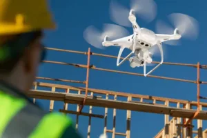
This is also the case in the surveying industry. In recent years, there has been a growing trend of using drones for surveying projects, big and small. This futuristic device provides many advantages over traditional methods.
Here’s a look at how drones are changing the surveying landscape:
1. Drones are more efficient.
In the past, land surveys are conducted using conventional methods. But these devices have limitations — they can be slow and take a lot of time for surveyors to use.
On the other hand, drones allow for a more comprehensive survey to be conducted in a shorter amount of time. This is because drones can cover more ground faster in a fraction of the time it would take using ground-based methods. Aside from that, they can also access difficult-to-reach areas that would otherwise be inaccessible.
2. Drone surveys can be highly accurate.
One of the main advantages of using drones for surveying is that they can capture data with greater accuracy than ever before. Drones can capture precise data thanks to their high-quality cameras and sensors. Moreover, the data collected by drones are highly functional. They can be used for various purposes, from mapping to 3D modeling.
3. Drones are less expensive.
If you’re working on a tight budget, then you’ll be happy to know that drones are much less expensive than other surveying methods. Some estimates show that using drones for land surveying can save up to 80% compared to traditional methods when surveying large areas.
With the help of drones, you no longer need to rent a helicopter or pay for fuel and extra equipment to survey the land. Instead, you can simply buy or lease a drone, which is much cheaper in the long run. In reality, they often pay for themselves very quickly th
anks to the money saved in their efficiency.
4. Drones are safer.
Another great benefit of drones is that they’re much safer than other methods — especially when surveying dangerous or hard-to-reach areas. With drones, surveyors do not need to risk their lives in traversing rough and dangerous terrain just so they can collect the necessary data.
Instead, they can stay at a safe distance while letting their drones do the work. Drones prevent work-related accidents from happening by not putting surveyors at risk in the first place.
5. Drones are changing how surveyors operate.
In the past, surveyors would have to go into the field with all their equipment and conduct a survey. This means they would need more extensive planning for their
site visits, considering the time, expenses, and other projects that make their work harder.
Today, surveyors can do the work they need with their drones and laptops. They simply need to have their drones fly over the area they want to
survey and get the data they need.
The Future is Now!
Drones are revolutionizing the surveying industry by changing how surveying is done and how surveyors work. These machines make land surveying more accurate, efficient, and faster while increasing safety and lessening expenses.
Drones have made a breakthrough in making the land surveying industry become better. Only the best and most qualified land surveying companies ensure that they use state-of-the-art devices coupled with their expertise. Hence, when looking for a land surveying company, ensure they can give you the expertise and excellent service you deserve.
Arc Surveys
Have any further questions about the advancements of Drone Surveys? Give us a call (403-277-1272) or drop us an email at [email protected]. We’ll help you get a better understanding on how to get the best information towards completing your next survey project.