Have you ever wondered what takes place behind the scenes to create a Real Property Report? If so, keep reading, we have outlined a few of those steps to help you along the way.
Step 1
A homeowner orders a Real Property Report (RPR) for their property. This often takes place during or before the sale listing of the home. A real estate ‘Sale Contract’ specifies that an RPR with compliance is needed to compete the sale. Once a job is confirmed and the order is taken, a file is set up detailing the information needed to start the survey.
From here the RPR is added to our workflow and assigned to a field survey crew to be completed in a timely fashion.
Step 2
The field surveyors are the ones you will see on the property, outside your home, or in your backyard. It’s important to note that all our work is completed on the exterior of your home. Typically, no measurements are needed on the inside.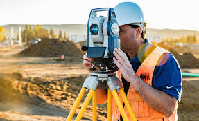
Once on location, the field surveyors will assess the property to determine the best place to set up their equipment. Usually, this consists of a Total Station and other equipment needed to complete the work. Total stations are those tripod-like pieces of equipment that you’ve seen before on construction sites.
Step 3 Surveying the home.
Reference points are placed in the sidewalk or in the front of your house and marked with orange flagging and/or paint. No, these markings are not your property lines. They are simply used as reference points for the equipment setup. If paint was used it will eventually fade with the weather and you will forget they were ever there.
As mentioned before a Total Station is used to take specific measurements of your house and other objects on property. This information is collected and recorded in a data collector.
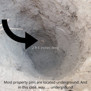
Metal detectors are used to locate property posts that can be buried deep in the ground. Many times these metal posts are located at the corners of your property at the front and back. But this is not always the case, as time and on-going construction can completely remove or wipeout the location of these posts. Once located, a small hole is dug in the ground to expose the property post. Once the location of the post is measured it is then reburied again.
Do we use GPS? we sure do!
When applicable our surveyors will often use a long pole with a GPS located on the top to pinpoint the exact location of objects within your yard. Such as the corners of a fence or maybe the edge of a patio or retaining wall.
Lastly, a complete measurement of all structures on the property is completed by hand and drawn on paper or digitally. See the example below.
The field surveyor crew will gather the information needed in a few different stages but for the most part, will be onsite for a few hours to complete the surveying portion of the Real Property Report.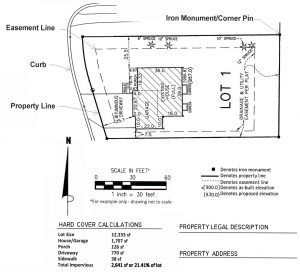
Step 4
Once the field survey is completed, all the information gathered on location is downloaded at our office location.
From here the data is used by a drafting technician to create a digital Autocad drawing reflecting the survey and fieldnotes of the survey crew.
The information collected in the field is used during the drafting process to calculate things such as the position of the home in reference to the boundaries, the location of property corners, municipal right-of-ways, encroachments, and any other permanent surface improvement on the lot.
Once the drafting process is complete each RPR is carefully checked by a professional Alberta Land Surveyor. If corrections or discrepancies are found, the RPR is sent back to the drafting technician to make the necessary revisions.
Step 5
Each Real Property Report is considered a legal copywritten document and must be a true representation of what is on the property, as per the Alberta Land Surveyors’ Manual of Standard Practice. For this reason, the professional Land Surveyor will not approve the Report until it meets or exceeds those standards.
Once the Land Surveyor is satisfied that the RPR is a correct representation of what is on the property, he will sign and stamp it. At this point your RPR is now complete and is ready for pickup, unless of course you asked us to submit for compliance with the City of Calgary.
Step 6 “if required”
City of Calgary compliance
Once completed, signed, and stamped we will send your RPR to the City of Calgary as requested. The City will review the RPR against City bylaws and will stamp each RPR with a blue compliance stamp if nothing is found that breaches their current bylaws. This process is simple and can be completed in a day or two, depending on their busyness.
Once completed the City of Calgary will send the RPR back to our office and we will notify you at once that your RPR is complete and ready to be picked up or delivered by your preferred method.
And that’s it!
Hopefully, we’ve been able to shed some light on the process of preparing a Real Property
Arc Surveys
We help you sleep better by providing Real Property Reports and Land Surveying solutions.