Understanding how to interpret boundaries, structures, setbacks, and encroachments.
A Real Property Report (RPR) is one of the most important documents in an Alberta real estate transaction. It establishes where buildings, fences, garages, and improvements sit in relation to the legal property boundaries. Reading an RPR correctly can help identify potential problems such as encroachments, non-compliant structures, issues that may delay sales, cause financing challenges, or result in legal or municipal requirements.
Although many homeowners, developers, and real estate professionals regularly interact with RPRs, interpreting them can be challenging. This guide explains how to read a Real Property Report using the provided RPR image, focusing on compliance issues, encroachments, and setback interpretation.
What is a Real Property Report?
A Real Property Report is a legal survey document prepared by a licensed Alberta land surveyor. It shows:
- The legal boundaries of the lot
- The location and size of visible improvements
- The distances (offsets) between improvements and property lines
- Any encroachments onto municipal or neighbouring land
- Notes related to rights-of-way, easements
- A certification statement from the surveyor
Municipalities such as the City of Calgary and the City of Edmonton use RPRs when reviewing compliance for land use and development. Some residential properties, including bare land condominium parcels, may require RPRs depending on the structures built on-site.
How to Read an RPR (Step-by-Step Walkthrough)
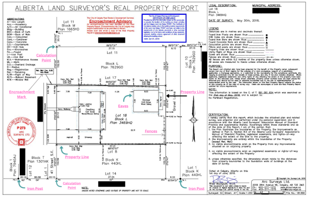
The following steps explain how to interpret the provided RPR image. References such as “as shown in the provided RPR image” indicate where each component appears visually.
- Start With the Legal Description & Municipal Address
In the top-right corner of the provided RPR image, the legal description identifies the property as:
- Lot 18
- Block L
- Plan 3469HQ
This legal description must match the Alberta Land Titles registry. The municipal address (“41 Street S.E., Calgary, Alberta”) confirms the physical location. If these do not align with the property being reviewed, the RPR is not valid for that parcel.
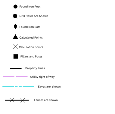
- Review the Legend & Abbreviations
In the provided RPR image, the legend explains how each symbol is used throughout the plan. Examples include:
The abbreviations list (bottom-left area) defines terms such as:
- B.O.C. (Back of Curb)
- Conc. (Concrete)
- Ret. (Retaining)
- R/W (Right-of-Way)
These notations appear throughout the RPR and help identify what materials or structures exist at each location.
- Review Bearings & Property Boundary Dimensions
As shown in the provided RPR image, each property line includes:
- A bearing (direction relative to north)
- A distance (length of that segment)
- Examine Structures and Their Offsets to Property Lines
RPRs show the location of structures such as houses, garages, decks, and landings.
In the provided RPR image:
- The dwelling footprint is drawn with offsets showing distances such as 7.59m, 7.32m, and 11.36m from property lines.
- The detached garage at the rear shows offsets to the lane and to interior property lines.
- Concrete walkways, concrete pads, and landings are shown as well. These offsets are what municipalities use to determine whether structures meet required setbacks in the applicable Land Use District.
- Identify Rights-of-Way, Easements & Registered Instruments
The provided RPR image includes several references to existing registrations affecting the land:
- A party wall agreement
- A retaining wall note
- Reference to nearby utility rights-of-way
Curious to see the image that is being referenced for the above
These registered instruments may limit construction or impose obligations on the property owner. They should always be compared with the actual Alberta Land Title for accuracy.
- Locate Encroachments
An encroachment occurs when a structure extends over the property boundary onto municipal or private land.
The provided RPR image includes a City of Calgary Encroachment Advisory, stating that one or more improvements extend into City property. The advisory requires review by municipal staff and may require an encroachment agreement Calgary.
Common encroachments visible in RPRs include:
- Fences built beyond property lines
- Concrete pads projecting into municipal land
- Retaining walls affecting the right-of-way
- Driveways extending over the boundary
- Garage eaves or overhangs crossing the lot line
In the provided image, the encroaching elements are highlighted near the rear lane area.
- Interpret Setbacks & Potential Compliance Issues
Compliance issues arise when an improvement does not meet setback distances, sits within a right-of-way, or lacks the required permit.
In the provided RPR image, consider whether:
- The garage is placed too close to the lane
- The eaves extend beyond allowed projections
- The retaining wall impacts municipal land
- A walkway or concrete feature crosses a boundary
- The dwelling meets side yard setbacks
Non-compliant structures may trigger conditions such as:
- Need for a development permit
- Requirement for removal, modification, or variance
- Additional review during resale
- Ineligibility for a Certificate of Compliance
Cross-checking setback distances with the City of Calgary Land Use Bylaw confirms whether structures meet current standards.
Encroachments: Definition, Examples & Impacts
What Counts as an Encroachment in Alberta?
An encroachment is any structure that extends beyond the property boundary.
Typical Encroachments on RPRs:
- Fences
- Retaining walls
- Eaves, bay windows
- Driveway edges
- Concrete pads or walkways
Legal & Transactional Implications:
- Municipality may require an encroachment agreement
- Buyer’s lawyer may require resolution before closing
- Insurance may not cover unpermitted structures
- Encroachments may affect property value or marketability
Next Steps When Issues Are Found
- Engage a licensed Alberta land surveyor to update the RPR if improvements were added or altered.
- Request permit history from municipal planning departments.
- Apply for an encroachment agreement if improvements extend onto municipal land.
- Consult a real estate lawyer for agreements affecting title.
- Confirm zoning and setbacks using municipal resources.
- Seek a variance or development permit to regularize non-compliant structures.
- Address required corrections before listing or refinancing the property.
Land Survey Costs & Choosing Providers
The land survey cost in Calgary or Edmonton varies based on complexity, property size, age of neighbourhood, and title research requirements. Infill and irregular lots generally require more fieldwork, increasing cost.
When selecting a provider, reputable surveyors, Calgary, surveyors Edmonton, or Calgary land survey companies should be chosen based on experience preparing real property reports within Alberta.
Example of a RPR/Legend of RPR